TGViewer
Geoalert Blog Geoalert Blog @geoalert · 413 subscribers
Post #877 56
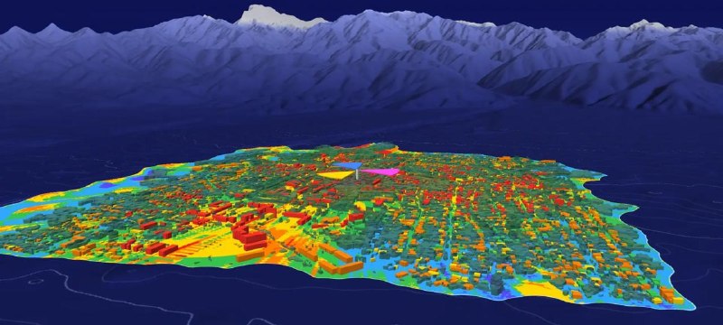
From terrain to a radio plan, then kept current

1. Load the terrain
Start from a terrain model of the area: Copernicus GLO-30 or the elevation data you already use.
2. Generate the city from fresh imagery
Mapflow classifies land use and extracts every building and tree, with its height, from recent satellite imagery.
3. Plan the radio network
Load the layers into your planning tool and predict coverage on the city as it stands today. (We convert data into Atoll's or other software formats)
4. Update only what changed
When new imagery shows a change, such as this construction site, Mapflow re-maps only that area and you recalculate the network.

👉 Learn more about Mapflow Telecom tailored solutions.
👉 Request us to run a demo or pilot project in the area of your network.
  • 👍 3
  • 🤩 2
More from @geoalert
  1. Oct 13, 2026🚗 Mapflow Roads Model — Update! We've released a significantly improved version of our Ro…
  2. Oct 9, 2026🚀 AOI list management further improvements While you're viewing the processing results ("…
  3. Oct 6, 2026🧑‍🤝‍🧑Team management, redesigned To tell the truth it didn't go well with the user's ad…
  4. Oct 2, 2026🌲 Forest and trees workflow was updated with two models, both benchmarked against thoroug…
  5. Oct 1, 2026📍AOI management update Have a long list of areas to map? You can process them one by one,…
  6. Sep 25, 2026🌳 How many trees are in New York’s Central Park—and what can we learn from imagery? The s…
Threads Profile ViewerView any public Threads profile without an account.Open ThreadLook →Writing with AI? Make it sound human.Metric37 rewrites AI drafts so they read naturally. Free AI detector, 1,500 words free.Try Metric37 →