TGViewer
Clash Report Clash Report @clashreport · 110K subscribers
Post #98731 4.21K
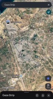
Google Maps updated its default satellite imagery for Gaza to January-February 2026 captures, making the scale of destruction immediately visible to anyone opening the app.

The 2026 tiles show dense residential blocks in Rafah and Khan Younis reduced to gray rubble fields, Al-Shifa Hospital area heavily altered, and massive tent camps on remaining open ground.

UNOSAT's latest count: 201,290 damaged structures (82% of all buildings), 134,422 destroyed.

The imagery covers ~235 km² at ~13 cm resolution — sharp enough to see individual walls and tent clusters.

Apple Maps has not made an equivalent update.
  • 🤬 61
  • ❤ 19
  • 🔥 11
  • 😢 9
  • 👏 7
  • 💔 3
  • 🤣 2
  • 😈 2
  • 👍 1
More from @clashreport
  1. Sep 28, 2026Defense Secretary Pete Hegseth has ordered the Pentagon to use intelligence, cyber operati…
  2. Sep 28, 2026Trump: Axios just released a story that “Trump” offered Sanctions Relief and Frozen Funds…
  3. Sep 28, 2026Netanyahu's Office: Netanyahu and his wife visited the United Arab Emirates yesterday at t…
  4. Sep 28, 2026The U.S. Navy’s USS Santa Barbara required urgent repairs in Singapore after documents war…
  5. Sep 28, 2026Mediapart alleges that National Rally leader Jordan Bardella made antisemitic and conspira…
  6. Sep 28, 2026UAE says President Sheikh Mohammed bin Zayed received Netanyahu on Sunday, with the "two d…
Threads Profile ViewerView any public Threads profile without an account.Open ThreadLook →Writing with AI? Make it sound human.Metric37 rewrites AI drafts so they read naturally. Free AI detector, 1,500 words free.Try Metric37 →