TGViewer
Channel Public Channel
Kerala

Kerala

@kerala

🏝 Welcome To God's Own Country πŸ–
🐘 ΰ΄¦ΰ΅ˆΰ΄΅ΰ΄€ΰ΅ΰ΄€ΰ΄Ώΰ΄¨ΰ΅ΰ΄±ΰ΅† സࡍഡനࡍഀം ΰ΄¨ΰ΄Ύΰ΄Ÿΰ΅β€Œ 🌴
- @Kerala
Subscribers
8.51K
Photos
12
Videos
0
Links
1.1K

Showing posts older than #1223 Β· Back to latest

Older Posts 20 shown
Post #1222 19.9K
​​Chimmini Dam

Chimmini Dam is situated in Echippara in Chalakudy taluk of Thrissur District of Kerala state of India. It is constructed across Kurumali river, a tributary of the Karuvannur river.[1] Chimmini is the largest dam of Thrissur district. The Chimminy Wild Life Sanctuary is located close to the dam.[2] Construction of the 495-metre masonry and 686-metre earthen dam started in 1975 and it was completed in 1996. Total cost of the project was Rs 59.71 crore although the cost of construction of the dam was initially estimated at Rs 36.15 crore. The reservoir attract tourists and there are coracles ride available at the reservoir.[4] The dam was commissioned in 1996. One uniqueness about this dam is the absence of canal system. The water contained in the reservoir is made available to the Kole fields and paddy fields by means of the river and the existing canal system through a regulator. No artificial canal system was set up for this purpose.
━━━━━━━━━━━━━
🏝 @Kerala | @Malayalam πŸ₯₯
  • πŸ‘ 4
  • ❀ 3
  • πŸ‘ 2
Post #1221 18.8K
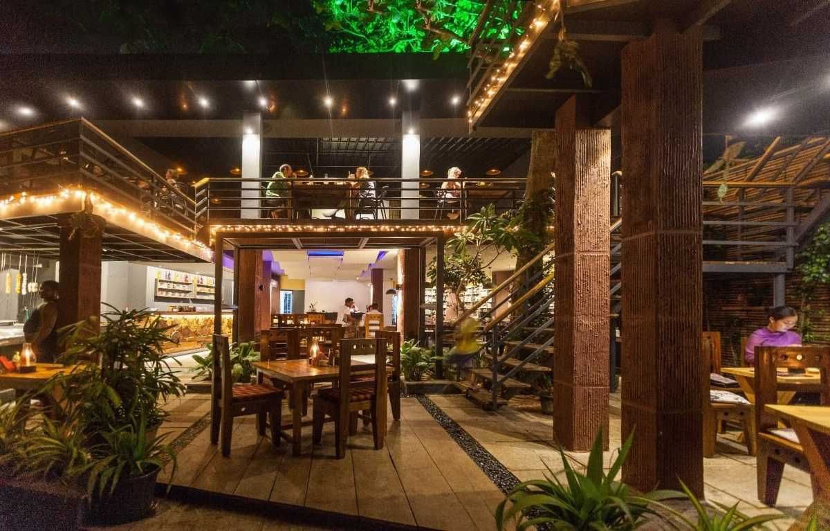
​​Cafe Italiano

If you are up for sipping on coffee amongst the greenery, then Cafe Italiano is among the best cafes in Varkala that you can choose! Housed in wooden interiors, the location of the cafe is pleasant as it provides a magnificent sea view. Designed with an in-house mini library, this cafe is best to visit in the evening.
━━━━━━━━━━━━━
🏝 @Kerala | @Malayalam πŸ₯₯
  • ❀ 4
  • πŸ‘ 4
  • πŸ”₯ 2
  • πŸ₯° 1
Post #1220 17K
​​Choornikkara

Choornikkara is a census town located in Aluva in the Ernakulam district of Kerala, India. It is also the headquarters of the Choornikkara Gram Panchayat. As of 2001 India census, Choornikkara had a population of 36,998. Males constitute 50% of the population and females 50%. Choornikkara has an average literacy rate of 83%, higher than the national average of 59.5%; with male literacy of 85% and female literacy of 80%. 11% of the population is under 6 years of age.
━━━━━━━━━━━━━
🏝 @Kerala | @Malayalam πŸ₯₯
  • πŸ‘ 2
  • πŸ”₯ 2
  • ❀ 1
  • πŸ‘ 1
Post #1219 17.7K
​​Fort Emmanuel

Fort Emmanuel, also known as Fort Manuel, is a ruined fort located at Fort Kochi Beach in Kochi (Cochin), Kerala, India.[1] It was built by the Portuguese to be a bastion & a symbol of the strategic alliance between the Kingdom of Cochin and the Kingdom of Portugal.[2] Named after Manuel I of Portugal, it was the first European fort built in Asia. In September 1503, the King of Kochi granted permission to Afonso de Albuquerque to build Fort Emmanuel near the waterfront of the Arabian Sea. The construction was commenced on 26 September, and "it took the shape of a square with flanking bastions at the corners mounted with ordnance". The walls were made of double rows of coconut tree stems securely fastened together and with earth rammed firmly between; it was further protected by a wet ditch. The fort was christened on the morning of 1 October 1503 "Emmanuel", after the King of Portugal.
━━━━━━━━━━━━━
🏝 @Kerala | @Malayalam πŸ₯₯
  • ❀ 3
  • πŸ‘ 3
  • πŸ”₯ 1
Post #1218 14.9K
​​Kodungallur

Kodungallur (Malayalam: [koΙ–uŋːɐlːuːr]; formerly also known as Cranganore (anglicised name), Cranganor (Portuguese), Mahodayapuram, Shingly, Vanchi, Muchiri, Muyirikkode, and Muziris) is a historically significant town situated on the banks of the river Periyar on the Malabar Coast in Thrissur district of Kerala, India. It is 36 kilometres (22 mi) north of Kochi (Cochin) by National Highway 66 and 38 km (24 mi) from Thrissur. Kodungallur, being a port city at the northern end of the Kerala lagoons, was a strategic entry point for the naval fleets to the extensive Kerala backwaters. As of the 2011 India Census, Kodungallur Municipality had a population of 33,935. It had an average literacy rate of 95.10%.[2] Around 64% of the population follows Hinduism, 32% Islam and 4% Christianity. Schedule Caste (SC) constitutes 7.8% while Schedule Tribe (ST) were 0.1% of total population in Kodungallur.
━━━━━━━━━━━━━
🏝 @Kerala | @Malayalam πŸ₯₯
  • πŸ”₯ 3
  • ❀ 2
  • πŸ‘ 2
  • πŸ‘ 1
Post #1217 2.24K
🎈Is your english not as good as you wish it should be?

🎈Do you want to practice english but can't due to various circumstances?

🎈 Do you wish to learn english in a fun and easy manner?

πŸ“« To solve the above issues join us and start learning

https://t.me/chatting

▢️ Join @Chatting

🚨 Rules for chatting 🚨
Post #1216 13.6K
​​Venduruthy Bridge

Venduruthy-Vikrant Bridge, also known as Venduruthy Bridge is a bridge in Kochi, Kerala, India. There are two bridges at present; one railway bridge and one road bridge, running parallel to each other, that connects the Ernakulam side of Kochi to the Willingdon Island. The old Venduruthy railway bridge was constructed in 1938 along with two parallel road bridges. The old railway bridge is one of the first bridges in India to be completely constructed from steel. It is a landmark in Kochi with historic significance as it played a major role in the transformation of Kochi into a major port city in India during the British era. In 2005, a dredger hit the railway bridge which led to its closure. Following this incident, the construction of a new railway bridge started, which was opened in 2015. The old railway bridge was dismantled in March 2018. The new two-lane road bridge was opened in 2011, after the old road bridge was found to be too weak to carry heavy vehicles.
━━━━━━━━━━━━━
🏝 @Kerala | @Malayalam πŸ₯₯
  • ❀ 5
  • πŸ‘ 3
  • πŸ”₯ 1
Post #1215 12.1K
​​Manjapra

Manjapra is a village in the Ernakulam district of Kerala, India. It is located about 10 km from Angamaly and 6 km from Kalady. Chandrappura and Vadakkumbhagom are the main business centers. If you look at Manjapra from the sky, it looks like an island surrounded by paddy fields on all sides. The unique geographical feature of Manjapra is that all four entry points to this panchayat are from a padam (cultivated paddy field) and stream of water called as Thodu. The first entry point is Kuzhiampadam from Kalady town, the second is Karingallikkadu padam from Angamaly town, the third is Naduthodu from Neeleswaram panchayat and the last is Kothayipadam from Azyampuzha panchayat. Another famous agriculture hub is Mularippadam, near Chandrapura.
━━━━━━━━━━━━━
🏝 @Kerala | @Malayalam πŸ₯₯
  • ❀ 2
  • πŸ‘ 2
  • πŸ”₯ 1
  • πŸ‘ 1
  • 😱 1
Post #1214 13.5K
​​Angadipurram

Angadippuram is a census town and major suburb of Perinthalmanna town, in the Malappuram District of Kerala.It was the capital of the powerful medieval kingdom of Valluvanad. Angadippuram is also known for Angadippuram Laterite, a notified geo-heritage monument. Angadippuram is famous for its two temples, the Thirumandhamkunnu Temple and the Tali Mahadeva Temple. Kozhikode - Palakkad National Highway 966 passes through the town and Angadipuram Railway Station is one of the major railway stations on the Nilambur - Shornur Line of Palakkad Division, Southern Railways. It is connected to the major cities Kochi and Thiruvananthapuram by this line.
━━━━━━━━━━━━━
🏝 @Kerala | @Malayalam πŸ₯₯
  • ❀ 4
  • πŸ‘ 4
  • πŸ”₯ 1
Post #1213 14.9K
​​Pulpally

Pulpally is a mid-sized town in the Wayanad District of Kerala, India. Pulpally is also known as 'The land of black gold'. It is also renowned for its pure wild Wayanad honey. The famous Seetha Devi temple in Kerala is located in Pulpally. Geographically, it is a small town in Sultan Bathery Taluk and a Grama Panchayat under the local self-governance system. It is about 24 km from Sultan Bathery, and is almost surrounded by forest. The main source of income is agriculture. About 7 km from Pulpally is the place of death of Pazhassi Raja who led the famous Pazhassi Revolt against the East India Company during the 18th century and was killed on 30 November 1805.[3] The death place of Pazhassi Raja is called Mavilanthodu near Vandikadavu.This land had relations with the Indian epic Ramayana, it is said the goddess Sita Devi and her 2 sons, Kusha and Lava lived here.
━━━━━━━━━━━━━
🏝 @Kerala | @Malayalam πŸ₯₯
  • πŸ‘ 4
  • ❀ 1
  • πŸ”₯ 1
Post #1212 15.6K
​​Bharath Coffee House

Bharath Coffee House is an Indian restaurant in Kochi, Kerala. Located in Broadway, the restaurant was founded by B. Govinda Rao in 1956. It is one of the oldest restaurants in Kochi, which is still functioning. Bharath Coffee House was founded by B Govinda Rao. Actress Kamini Kaushal officially inaugurated it on 26 January 1956. Rao was a former employee of the Coconut Development Board and became a hotel's partner. The building of the hotel which dates back to 1919 was owned by several people over time. It was ultimately purchased by Rao who started the hotel. It soon rose to prominence as a favoured hangout, especially for young people, businesspeople, and musicians. It also became a meeting place for coffee and chatter.
━━━━━━━━━━━━━
🏝 @Kerala | @Malayalam πŸ₯₯
  • ❀ 3
  • πŸ‘ 3
  • πŸ”₯ 1
Post #1211 18.6K
​​Panathady

Panathady is a village in Kasaragod district in the state of Kerala, India. Panathady Panchayat is in Vellarikundu taluk. It is located 35 kilometers from the nearest municipality, Kanhangad, and 7.5 kilometers from the Kerala-Karnataka border town, Panathur. Politically, Panathady is included in the Kanhangad legislative assembly and Kasaragod Loksabha assembly.
━━━━━━━━━━━━━
🏝 @Kerala | @Malayalam πŸ₯₯
  • ❀ 4
  • πŸ‘ 4
  • πŸ”₯ 1
Post #1210 19.2K
​​Kadamakkudy Islands

Kadamakkudy Islands is an island suburb of the city of Kochi in the Indian state of Kerala. It is situated around 8 km (5 mi) north of the city centre. Kadamakkudy Islands is a cluster of fourteen islands: Valiya Kadamakudy (the main island), Murikkal, Palyam Thuruth, Pizhala, Cheriya Kadamakudy, Pulikkapuram, Moolampilly, Puthussery, Chariyam Thuruth, Chennur, Kothad, Korambadam, Kandanad and Karikkad Thuruthu.

The Grama panchayth is administered under the kerala Panchayth Raj system and the present administrators are The President Smt Shalini Babu and The Panchayth Secretary Sri Dylan Tom
.
━━━━━━━━━━━━━
🏝 @Kerala | @Malayalam πŸ₯₯
  • ❀ 8
  • πŸ‘ 3
  • πŸ”₯ 2
Post #1209 17.1K
​​State Highway 11 (Kerala)

State Highway 11 (SH 11) is a State Highway in Kerala, India that starts in Kalarcode, Alappuzha and ends in Perunna, Changanassery.The road is popularly known as AC road (Alappuzha Changanassery) road. The highway is 24.2 km long The Alappuzha-Changanassery Road was the concept of Sri. K. M. Korah, minister in the C. Kesavan ministry. Unlike other state highways, this road is unique, because 99% of the road is new road and not a conversion of existing pathways or village roads. It was completed and opened for traffic in 1958 by Sri. E.M.S Namboothiripad, the first Chief Minister of Kerala State. The road has been constructed parallel to the AC (Alappuzha-Changanassery) canal which is man made. Since the road was made through the paddy fields of Kuttanadu area, where paddy cultivation is done below sea level, the whole road is a reclaimed land made on the soil collected from the paddy fields received when the canal was made in the paddy field.
━━━━━━━━━━━━━
🏝 @Kerala | @Malayalam πŸ₯₯
  • ❀ 5
  • πŸ‘ 2
  • πŸ”₯ 2
  • πŸ‘ 2
Post #1207 12.6K
​​RP Mall, Kollam

The RP Mall is a shopping mall in the city of Kollam, Kerala, owned by one of the business tycoons in India, B. Ravi Pillai's RP Group. The Mall is located on Kollam's high street. RP Mall was formerly known as K-Mall (Kollam Mall). RP Mall has about 295,000 sq ft (27,400 m2) of retail space, spread on seven floors. There is a 2,700 sq ft (250 m2) McDonald's restaurant.
━━━━━━━━━━━━━
🏝 @Kerala | @Malayalam πŸ₯₯
  • ❀ 4
  • πŸ‘ 4
  • πŸ”₯ 2
  • πŸ‘ 1
Post #1206 13.5K
​​Pazhanji

Pazhanji is a village with near Kunnamkulam in Thrissur district in the state of Kerala, India.[1] The name "Pazhanji" is derived from the Malayalam word for "old". As of 2001 India census, Pazhanji had a population of 13,339 with 6,352 males and 6,987 females. Pazhanji is in the Kattakambal panchayat. Pazhanji is well known for its areca nut market and Pazhanji Palli / Pazhanji Church. The market is a hub for areca nut merchants from Monday through Saturday. This is where local areca nut (ΰ΄…ΰ΄Ÿΰ΄―ΰ΅ΰ΄•ΰ΅ΰ΄•) sellers sell their product to authorised areca nut merchants. Buyers and sellers execute trade transactions by auction. Daily operations commence at 8 am and continue until 10:30 am. The place is located in the Kattakambal Gram Panchayath.
━━━━━━━━━━━━━
🏝 @Kerala | @Malayalam πŸ₯₯
  • ❀ 4
  • πŸ‘ 3
  • πŸ”₯ 2
  • πŸ‘ 1
Post #1205 13.2K
​​Periyar River

Periyar, (Malayalam: [peɾijaːr], meaning: big river) is the longest river and the river with the largest discharge potential in the Indian state of Kerala. It is one of the few perennial rivers in the region and provides drinking water for several major towns. The Periyar is of utmost significance to the economy of Kerala. It generates a significant proportion of Kerala's electrical power via the Idukki Dam and flows along a region of industrial and commercial activity. The river also provides water for irrigation and domestic use throughout its course besides supporting a rich fishery. Due to these reasons, the river has been named the "Lifeline of Kerala".Kochi city, in the vicinity of the river mouth, draws its water supply from Aluva, an upstream site sufficiently free of seawater intrusion. Twenty five percent of Kerala's industries are along the banks of the Periyar. These are mostly crowded within a stretch of 5 kilometres (3 mi) in the Eloor-Edayar region (Udhyogamandal), about 10 kilometres (6 mi) north of Kochi harbor.
━━━━━━━━━━━━━
🏝 @Kerala | @Malayalam πŸ₯₯
  • ❀ 3
  • πŸ‘ 2
  • πŸ”₯ 1
  • πŸ‘ 1
Post #1204 12.5K
​​MahΓ© River

The Mahe River (/ˈmɑːheΙͺ/) natively Mayyazhipuzha (Malayalam: [mɐjːɐɻipːuɻɐ]) is a river in South India. It flows through the state of Kerala and the coastal exclave of Mahe in Puducherry. The Mahe River originates in the slopes of the Western Ghats part of the Wayanad district. Initially, the river flows through the hilly eastern towns of the Kozhikode district like Vilangad, Vanimal, Jathiyeri and Nadapuram. Then, the river enters into the Malabar plains where it flows through several towns, including Parakkadavu, Kadavathur, Peringathur, Eramala, Kunnukara, Kariyad and Peringandoor. The river then flows through the northern boundary of the Union Territory of Mahe and empties into the Arabian Sea.
━━━━━━━━━━━━━
🏝 @Kerala | @Malayalam πŸ₯₯
  • ❀ 3
  • πŸ‘ 3
  • πŸ”₯ 2
  • πŸ₯° 1
Post #1203 12.2K
​​Dharmadom

Dharmadom or Dharmadam is a census village in Thalassery City in Kannur district in the state of Kerala, India. This town is located in between Anjarakandi River and Ummanchira River, and Palayad town and Arabian Sea. It is known for the 100-year-old Government Brennen College, Dharmadam Island, Government Boat Jetty and adjoins famous Muzhappilangad beach. Dharmadom is a scenic coastal town that was earlier known as "Dharmapattanam". It was an active Buddhist area in ancient times.Arabs called it as Darmaftan.

Dharmadom is also home to famous Andalurkavu temple. The annual festival here draws thousands of devotees. A variety of Theyyam is performed at this event. India’s premier circus Academy, Circus Academy Thalassery is also located in Dharmadom
.
━━━━━━━━━━━━━
🏝 @Kerala | @Malayalam πŸ₯₯
  • ❀ 2
  • πŸ‘ 2
  • πŸ”₯ 1
  • πŸ‘ 1
Post #1202 12.2K
​​Thangal Para

A mythological destination and place of tourist importance - 'Thangal Para' is primarily a Muslim pilgrimage centre, about 5 kilometre from the Vagamon town at Kolahalamedu in Idukki district. As per legends, a Sufi saint from Afghanistan, Husrath Sheikh Fariduddin Baba came to Kerala around 800 years ago and this rock is supposed to be his 'Dargah' or the final resting place. The unique stone formation is situated at an altitude of 2,500 metres, and the spherical shape is believed to have gradually formed after the saint’s death. The belief is it was on this rock, which was once small, that the Sufi saint used to grind his paan or betel nut. To everyone's surprise, the water source between the cracks of the rocks does not seem to dry even during the summer season. For the pilgrims, there is a small prayer centre, where tourists are also allowed to enter. This place which is accessible by jeep is also a trekker's paradise, where you can journey through the muddy and rocky roads.
━━━━━━━━━━━━━
🏝 @Kerala | @Malayalam πŸ₯₯
  • ❀ 7
  • πŸ‘ 2
  • πŸ”₯ 1
  • πŸ₯° 1
Older posts β†’
Threads Profile ViewerView any public Threads profile without an account.Open ThreadLook β†’Writing with AI? Make it sound human.Metric37 rewrites AI drafts so they read naturally. Free AI detector, 1,500 words free.Try Metric37 β†’