
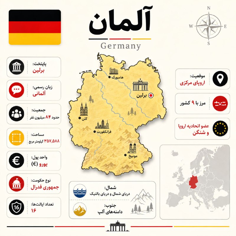
Create a highly accurate, premium square geographic infographic about:
COUNTRY: [آلمان]
Use the attached Germany infographic ONLY as the visual reference for:
- layout
- composition
- hierarchy
- card design
- spacing
- icon style
- map treatment
- typography scale
- overall editorial look
Do NOT copy Germany-specific facts, map, cities, landmarks, symbols, or colors.
Rebuild the same design system for [COUNTRY].
First, search the web and verify all key facts using reliable sources such as official government sources, national statistics offices, the UN, the World Bank, and reputable geographic institutions.
Do not guess any fact.
Verify and use:
- Persian country name
- English country name
- official flag
- capital
- official language(s)
- population
- area
- currency
- form of government
- number of first-level administrative divisions
- geographic region
- number of bordering countries
- 2–3 international memberships
- 4–5 important cities
- 2 major geographic features
All Persian text must be correct, clean, short, readable, RTL, and free of spelling mistakes or gibberish.
VISUAL STYLE:
Create a clean, premium, minimal-but-energetic editorial infographic:
- square 1:1
- warm ivory / cream background
- modern atlas aesthetic
- simple, elegant, uncluttered
- strong hierarchy
- rounded white cards
- subtle shadows
- crisp outlines
- minimal decorative details
- visually lively but not busy
Use the COUNTRY FLAG COLORS as the accent palette.
The infographic should feel more energetic and attractive than a quiet vintage atlas, but still minimal and refined.
LAYOUT:
TOP LEFT:
Official flag in a rounded rectangle.
TOP CENTER:
Large bold Persian country name
small decorative lines in flag colors
English country name below in elegant serif style
TOP RIGHT:
Minimal compass rose
CENTER:
Large accurate country map as the main hero element
- strong clean outline
- subtle terrain texture
- soft shadow
- colored with a soft version of a flag color
Inside the map:
- mark the capital with a distinct target marker
- label 4–5 important cities in Persian
- place cities approximately correctly
- add a few small relevant landmark illustrations only if necessary
- show only a few major geographic features, very subtly
LEFT COLUMN:
7 rounded white info cards:
1. پایتخت
2. زبان رسمی
3. جمعیت
4. مساحت
5. واحد پول
6. نوع حکومت
7. تعداد تقسیمات
Each card:
- colored circular icon
- subtle separator
- Persian label
- highlighted value in an accent color
RIGHT COLUMN:
3 compact cards:
- موقعیت
- مرز با [NUMBER] کشور
- عضویتهای مهم بینالمللی
BOTTOM RIGHT:
Locator map of the continent/region in pale gray
highlight only [COUNTRY] with a strong flag color
BOTTOM CENTER:
One clean geographic-features card with 2 rows showing the two most important natural/geographic characteristics of the country.
BOTTOM EDGE:
A thin decorative line in the country’s flag colors
with one small national architectural or geographic silhouette in the center.
IMPORTANT:
Keep the design minimal.
Avoid clutter.
Avoid too many icons, textures, labels, or decorations.
Make it visually attractive, energetic, and clear.
The result should feel very close to the reference image, but cleaner, simpler, and customized for [COUNTRY].
OUTPUT:
One polished square 1:1 infographic.
No watermark.
No unnecessary text.
No fake logos.
No gibberish Persian.
🔹 تلگرام . یوتیوب . توییتر . لینکدین
هوشمصنوعی در پژوهش، بروزترین گالری پرامپتهای جذاب هوشمصنوعی